

15 JULY 2023
In early July, the world’s oceans posted the highest average surface temperature ever recorded, a symptom of long-term warming combined with the onset of an El Niño pattern in the Pacific. The changed winds and ocean circulation patterns in an El Niño event distribute more of the Pacific’s heat to the surface, raising temperatures in the top layer of the water – and in the atmosphere. Heat stored in the ocean since the last El Niño in 2016 may make this year (or one of the next few) the hottest on record, according to leading meteorologists.
Early signs in the ocean include an “unprecedented peak” in sea surface temperature in the North Atlantic and a “dramatic drop” in the sea ice extent around Antarctica, according to the World Meteorological Organization (WMO). “We are actually at the beginning of [an El Niño pattern], so [it] hasn’t had as much of an effect as it is going to later in the year. So, we’re seeing these high temperatures in the North Atlantic . . . despite the fact that El Niño hasn’t really got going yet,” said Omar Baddour, Chief of Climate Monitoring at WMO.
The breadth of the surface layer warming spans the globe: Last month, NOAA reported that about 40 percent of the world’s oceans were warm enough to meet the definition of a marine heatwave, and that this fraction will likely increase to 50 percent by September.
“In our 32-year record, we have never seen such widespread marine heatwave conditions,” said Dillon Amaya, a PSL research scientist. “Normally we might expect only about 10% of the world’s oceans to be ‘hot enough’ to be considered a marine heatwave, so it’s remarkable to reach 40% or 50%.”
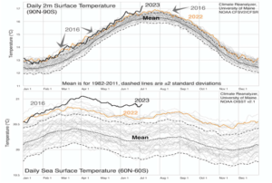
Kevin Trenberth / University of Maine / NOAA (CC BY SA)
The pattern is concerning when including temperatures on land: July 4 was the hottest global average day on record, and it quickly lost the title on July 6 and July 7. The first week of July may have been the warmest week ever recorded, according to Omar Baddour, Chief of Climate Monitoring at WMO.
More El Niño effects can be expected in the year to come, according to NOAA’s Physical Sciences Laboratory (PSL). Based on its experimental model for predicting ocean surface temperature, the PSL research team believes that it is likely that the El Niño pattern will intensify through the end of 2023. This could be accompanied by a marine heatwave off the Pacific Northwest and the Gulf of Alaska in 2024, similar to the one that devastated West Coast fisheries in 2014-16.
In Florida, experts are concerned that the last remaining live coral reefs in the Keys will sustain serious damage from heat this year. Sea surface temperatures in this region are at the highest for early summer since satellite sensing began, and the hottest spots have hit bathtub temperatures in the high 90s (F). Corals do poorly at temperatures above the high 80s, and extended periods of warm water can cause die-offs (bleaching).
“I have never been so worried for the future of Florida’s reefs,” veteran coral scientist Bill Precht told local station WFLA in Miami. “If greater than 90 percent of what’s left gets whacked, there will essentially be nothing left. . . . This is the scary reality. This is not science fiction.”


